Modelling tools
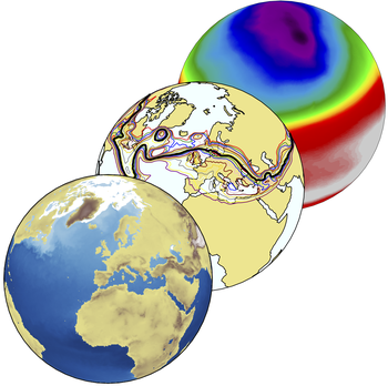
General Circulation Models
The Atmospheric Physics Group at UNIBO uses and maintains a hierarchy of General Circulation Models (GCMs) to study and address fundamental questions about the general circulation of the atmospheres and about the oceans and climate variability and change. These models feature an increasing level of complexity, ranging from atmospheric dynamic cores to fully coupled climate models and are run under various setups, going from idealized aquaplanet settings to 3D setups with realistic land and oceans configurations. The models we use are: the ICTP-AGCM, an intermediate-complexity atmospheric GCM, that can be coupled with a slab-ocean model or with the NEMO ocean model; the OPEN-IFS, the open version of the ECMWF operational Integrated Forecast System, that is a state-of-art atmospheric GCM.
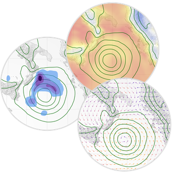
Mesoscale Atmospheric Models
Despite recent improvements in several General Circulation Models (GCMs), their spatio-temporal resolutions are still too coarse to capture atmospheric phenomena directly interacting with human activities. To achieve such detail, since the 1970s a new lineage of atmospheric models, the Regional Climate Models (RCMs), have been designed to exchange information from GCMs at the synoptic scale to the local scale. These models usually reduce the domain to limited areas to better represent the major processes associated with the surface, boundary layer, radiation, clouds and convection. One of the most widely used RCMs is WRF (Weather Research and Forecasting), provided by the National Center for Atmospheric Research (NCAR) and designed for both research and operational purposes. It is suitable for a broad span of applications across scales ranging from hundreds of kilometers to hundreds of meters, such as parameterized-physics research, regional climate simulations, air quality modeling, atmosphere-ocean coupling and simulations of idealized conditions.
Radiative Transfer Models
Radiative transfer modelling requires not only the mathematical treatment of the radiative transfer equations but also an accurate description of the microphysical and optical properties of the atmospheric constituent’s (gases, clouds, aerosols), and of the Earth surface properties. All these components are managed through a variety of different models and tools. The Atmospheric Physics group is involved in exploiting existing third-party codes as well as in developing internal tools for these tasks.
Surface emissivity models (Masuda)
Clouds and Aerosols properties models (Scattnlay, ssp_psd)
Radiative transfer computation models (LBLRTM, DISORT, LBLDIS, RTX, LIBRADTRAN, σ-IASI/σ-FORUM)
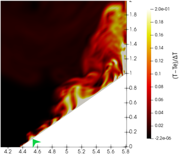
Computational Fluid Dynamics
OpenFOAM is an open-source software for computational fluid dynamics, written in C++ and provided with a large number of modules for simulating a variety of thermo-fluid flows at high resolution. Numerical approaches adopted are the Large-Eddy Simulation (LES) and Reynolds-Averaged Navier-Stokes (RANS) simulation. Standard solvers are modified and adapted to reproduce targeted physical processes, while a highly accurate turbulence model has been implemented for LES. A homemade solver for reproducing heat transfer between different media, water evaporation and condensation, thermal radiation is actively developed within the group.
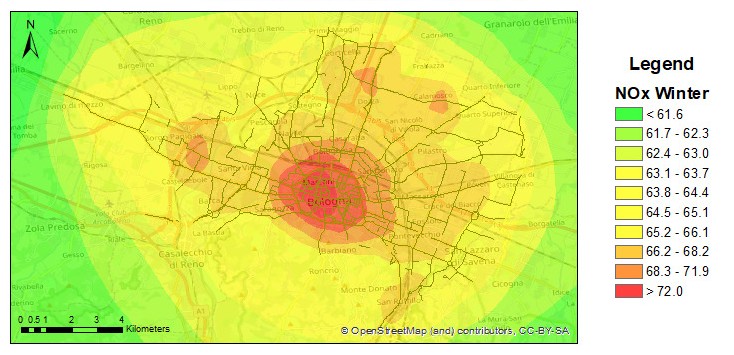
ADMS-Urban
ADMS-Urban (Atmospheric Dispersion Modeling System) is an advanced air pollution dispersion model developed by Cambridge Environmental Research Consultants (CERC), UK. The model allows the calculation of pollutants concentrations calculation emitted by a cityover a city area, considering explicitly the typical sources of an urban area (continuous point, linear, areal, volumetric sources, CERC, 2020) are explicitly considered. Additional modules are available that allow the treatment of complex terrain, elevation of the plume, presence of buildings and urban canyons, dry and wet deposition, simplified chemistry of nitrogen oxides (NOx-NO2) and includes a photochemical model for NOx and ozone.
The model was validated by the group on several European cities (Bologna, Vantaa, Hasselt) and used to evaluate urban planning policies aimed at improving air quality (iSCAPE D4.5) also hypothesizing future scenarios of climate change (iSCAPE D6.5).
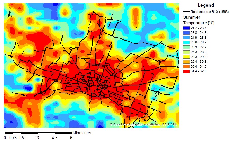
ADMS-TH
ADMS-Urban Temperature and Humidity module (ADMS-TH) derives the resulting distributions as a perturbation of an existing field. ADMS-TH provides the spatial distribution of the temperature and humidity field generated by spatial variations in land use, city morphology and anthropogenic heat emissions compared to unperturbed wind input values (CERC, 2018).
The model was validated on the city of Bologna during the i-SCAPE (www.iscape-project.eu) project and used to evaluate temperature variations in future climate change scenarios.
EMIT
EMIT (Emissions Inventory Toolkit, CERC, 2015) is a database tool for storing, manipulating and assessing emissions data from several sources (major roads, rail and industrial sources, minor road, commercial and domestic sources). EMIT stores emissions data that have been directly imported, or to calculate emissions from source activity data using emission factors. Alternately, EMIT can calculate emissions using a scaling of national or regional emissions by a local statistic such as population.